Bourgeau Lake and Harvey Pass

View from Harvey Pass, Banff National Park

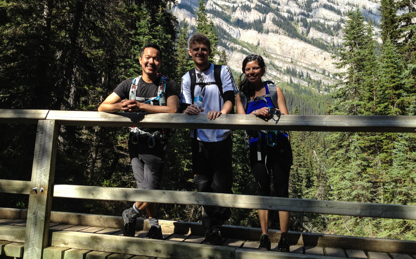
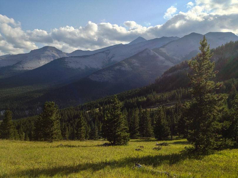
This hiking season has been about the “Classics“. In previous years, I was determined to “bag peaks”, or hit as many summits via scrambling as I could. But this year was a bit more tame. I opted for a more hiking approach: to spend lots of time in the outdoors, hike among different scenery and locations, and try to enjoy some of the hikes that Banff and Lake Louise have to offer. Earlier in the season, I’ve ventured to the Lake Agnes and Plain of Six Tea houses, hiked around Tunnel Mountain to the hoodoos in Banff, and got completely lost on the Cory Pass and Mount Edith Circuit. This past weekend, Shari, Bjorn and I would hike to Bourgeau Lake and Harvey Pass, which is another classic hike in Banff National Park.

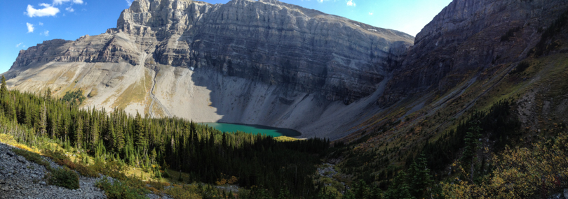
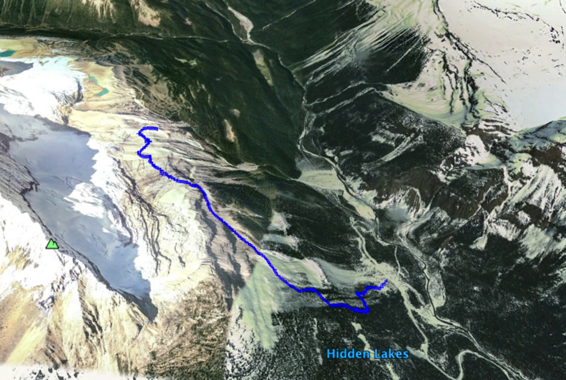
About 8 km west of Banff is the Bourgeau turn off. We parked, geared up, and began the hike. It was a late start, but we were in no rush. The first few kilometres through the forests on a well-travelled path seemed like it went on forever, but it was worth the trek to Bourgeau Lake. The backdrop of Mount Bourgeau was stunning! We plugged onward, ascending the rocky path toward Harvey Lake and the pass.

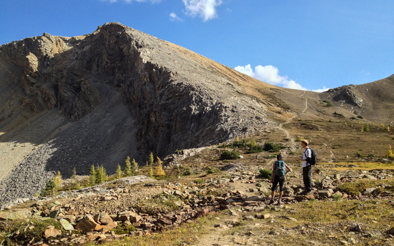
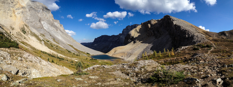
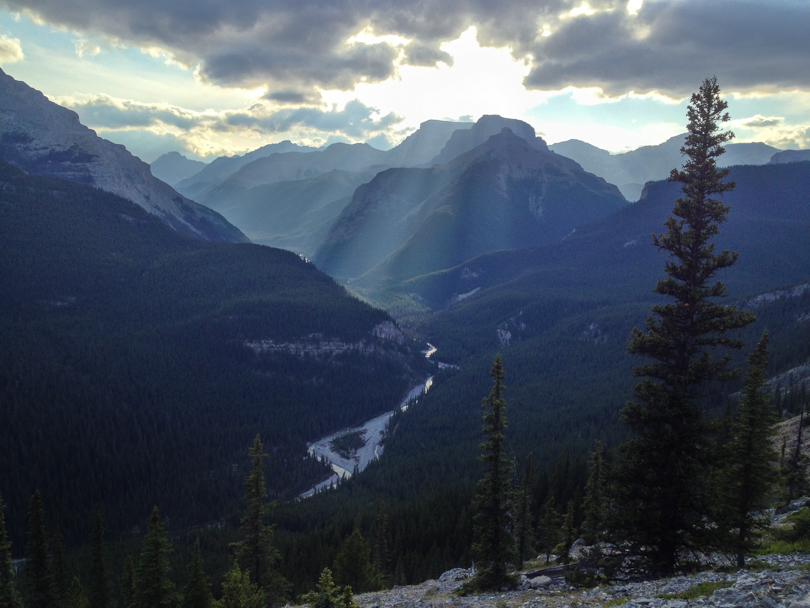
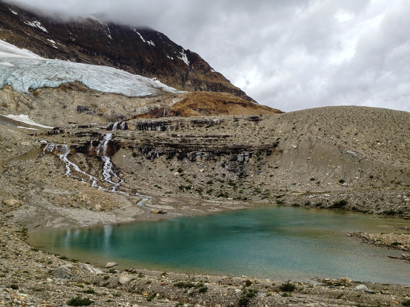
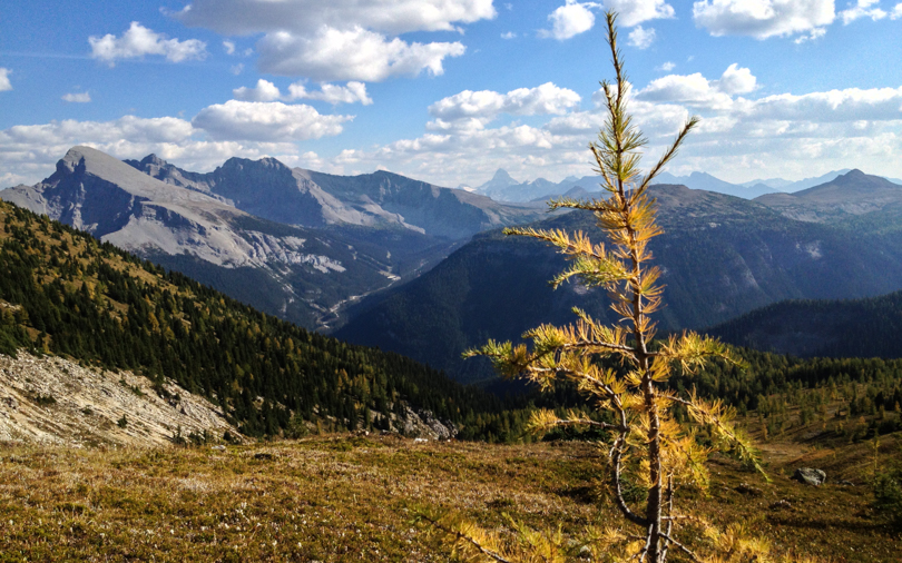
The section between Bourgeau Lake and Harvey Pass was gorgeous! Little waterfalls; green trees with golden grass and shimmering tarns lined the path toward the pass. Once we arrived, the view was beautiful. In the distance, Mount Assiniboine rose high into the sky. To our left, Mount Bourgeau taunted us, since it was too late in the afternoon to begin the summit ascent. We could see Sunshine Road and the gondola to the top of the mountain, which was crazy to see in the summer. I wonder what hikes are in that area! It was a long trip back to the car but the day trek was well worth it. The weather was beautiful and the company was great- ingredients for an awesome hiking day.

The only not so great thing? The black liquorice candies that Bjorn brought. Apparently they love them in Denmark, especially the salty kind. Thanks for sharing, Bjorn, but my palette was not ready for such an acquired taste!

Stats:

  • Start: 12:40 pm
  • End: 7:40 pm
  • Distance: ~ 19.8 km
  • Elevation gain: 1025 m
En route to Bourgeau Lake
Bourgeau Lake with Mount Bourgeau in the background
Ascending to Harvey Pass
View of an unnamed lake and the path to Harvey Pass
Ascending to Harvey Pass

Buller Pass

We made it! At Buller Pass

Saturday was hike #2 for the weekend. Fact: my ankles are weak now. Weak! Ever since ripping some ligaments in my left foot about a year ago, it has never been the same. Lo and behold, a short walk home from work earlier in the week would result in me spraining the same ankle again in a similar way. It’s been sore since then. My hope for Saturday’s hike was to take it easy on the ankle, so I strapped on the ankle brace from last year (it’s on its come-back tour), and a few of us headed to Buller Pass in Kananaskis.

Another fact: I very much dislike the gravelly Spray Lakes road. But it sure does lead to some amazing places!

View from Buller Pass. Ribbon Lake can be seen from here.

Buller Pass was a very nice day hike. Not super long with a bit of everything: forests (both alive and charred), a waterfall, a bridge or two (though one of them was out and replaced with a few logs for fording the water), a nice ‘meadow’, and a last push up a rocky slope to incredible views of the valley, mountains, Ribbon Lake, and Guinn’s Pass. Let me emphasis: the views are gorgeous! Of course, there was time for Shari, Robin, Bjorn, Robbie and I to take some photos… along with seemingly lots of other people. Who knew the hike was so popular?

The day ended with gorging on Grizzly Paw’s burgers and fries in Robin’s car because of a freak rain storm. Random, yes. But super tasty, nonetheless.

Stats:
Start: 12:45 pm
End: 6:10 pm
Distance: 15 km
Elevation of Buller Pass: 2485 m
Elevation Gain: 671 m

Buller Pass from Spray Lakes Road

Nihahi: The Best Dinner Spot in the World

I should eat dinner here every night :)
I should eat dinner here every night 🙂

Now this is a dinner spot with a view.

On Friday, Jess, Dave, Robbie and I headed out for an after work hike. I thought about going to Nihahi, which is where we ended up, but with the nights descending upon us earlier and earlier, we didn’t quite make it to the summit. That ended up being completely okay, though. We all packed sandwiches for dinner and by the time 7:00 pm rolled around, we decided to stop and feast. We chose a spot, about mid-way to the summit, facing west.

Such a pretty meadow!

I really do live in an amazing place. Calgary is a great city in its own right, but I love living here because of its proximity to the mountains. One minute, I’m working in the Statistics Canada data centre on main campus; the next, I’m eating dinner and overlooking the Elbow Valley while the sun sets behind the clouds and the expansive mountains ahead. The magnitude of the view was enough to create a reflective mood among the four of us, and in some ways, put us in our place. Not all dinners are that awesome in the true sense of the word.

The Iceline Trail and Takakkaw Falls

Glacier on the Iceline Trail

I can’t quite remember how I heard about the Iceline Trail, but it’s been on my list of hikes to do for quite some time. I had read that it is one of the most beautiful hikes to do in the Rockies. When I learn something like that, the hike gets added to the list!

Takakkaw Falls
Takakkaw Falls

Robbie and I headed out to Yoho National Park in BC expecting bright blue skies and lots of sunny weather. Well, that’s what The Weather Network had us believe. As we drove to the Takakkaw Falls area near Field, BC, it was anything but sunny sigh. We had cancelled this trip two weeks ago in fear of a rainy day, but we were determined to do this hike this time, rain or shine. We parked on the side of the road near the Whisky Jack Hostel, suited up, and then began the climb. The trail starts with a series of switchbacks through the trees. The incline is steep! Although I was dripping sweat at times, it was nice to emerge above the tree-line not too long after leaving the trailhead. Onward, there are beautiful views of Takakkaw Falls and a large glacier to the east. Once we reached the rocky area (noticeably rock deposits from a receding glacier), more glaciers came into view right in front of us. So awesome! We crossed little streams and glacial ponds and hiked our way to a false summit, which allowed for 360 degree views of the falls, glaciers, forests, mountain peaks and valleys. Gorgeous! It became quite chilly, so we headed back down and found a large rock where we ate lunch.

Building a cairn on the trail for all to see

As we were descending, we noted the ‘field’ of cairns along the route. “We should build a cairn!” So that’s what we did, right along the trail so hikers would know they were heading in the right direction. Not that it was obscure at that point, but we just wanted to create a cairn for fun that would be visible. As expected, we considered visual appeal, colour, accessibility, and dramatic background. In the end, it was definitely the best cairn there. (Note: I fully acknowledge that this is a biased opinion.) We left the mountain quite happy with our accomplishments- the hike, and our engineering skills. The return was quick, so we followed up the hike with a closeup visit to Takakkaw Falls. Nature is a pretty awesome force! That night, we had a wonderful dinner at the Truffle Pig… which I think is pretty much one of the only restaurants in Field… or so it seemed.

Robbie and I on the Iceline Trail

It turns out we didn’t reach the Iceline Summit, but that’s okay. The day was all about experiencing a nice hike, enjoying the views of the glaciers around us, and having a great day.  Of course, though, this means that we need to hike it again! Maybe as a loop next time. We definitely need to reach the Iceline Summit. And hopefully when we visit again, our cairn will still be there :).

Stats:

Start: 1:30 pm

End: 6:00 pm

Elevation Gain: ~ 650 m

Distance: 9.45 km

The Iceline Trail (non-loop). Well, almost the whole thing

Happy Birthday to Me!

Birthday BBQ
Birthday BBQ

So I celebrated my birthday this week… Happy Birthday, eek! Another year has gone by filled with many adventures, and though I had some set backs with work this year, I anticipate the coming year will be awesome. I think I’m going to create a “Things To Do While Thirty Two” list. It’s time to get back to my lists :). The name also has a nice rhyme to it…

Douglas Fir Trail near Edworthy Park

The weekend was very nice and low key filled with some lovely celebrations. A trip to the farmer’s market was a must, followed by a short hike of the Douglas Fir Trail in Calgary. I’ve always wanted to complete this short jaunt, and we added geocaching to the activities for some fun. Then a great evening BBQ was a win for food and gorging, but an epic fail in terms of logic. Epic. Fail. The next day, there was a trip to Banff for an afternoon and The Wolverine in the evening. And then on Monday, breakfast at Nellie’s and dinner at Cibo in the evening with friends (where I received an awesome painting!). As for my actual day, a wonderful dinner at Bonterra Trattoria with great company (dos!).  I think 32 is starting off quite nicely…

Fail. Apparently the BBQ had legs.