On Sunday, despite being ridiculously tired, Robbie and I headed out for a hike. We stopped at the Barrier Lake Visitor’s Centre in Kananaskis to ask about potential hikes. The parks guy was super helpful, and we decided on a short hike to Rawson Lake, which has been on my list of hikes to do in Alberta for quite some time! So off we went to Peter Lougheed Provincial Park and parked at the Upper Lake Day Use area near the Kananaskis Lakes. I was all decked out in my 70L backpack and new North Face backpacking boots. I figured it would be a good training day, seeing as my big Glacier trip is a week away!
Broken bridge across Sarrail Creek
The hike was nice and short. Due to the flooding, a bridge was completely out, and so it required “fording” of the Sarrail Creek to access the trail. (A quick google search has revealed that “fording” is the act of crossing a river or stream at a shallow place). Then it was a steady incline to the lake. Apparently we were just short of crossing paths with a moose! Although that would have been quite the site to see, it’s probably best that we didn’t encounter it.
That way to Rawson Lake!
The lake itself was beautiful- a common reaction to most glacial lakes I’ve hiked to. We stopped for a lovely lunch and contemplated hiking up to Sarrail Ridge for an even better view… but alas, we opted for a nice, easy day, and headed back to the car. It was definitely a nice day for a hike and the weather cooperated by not raining until we were done!
Having lunch at Rawson Lake
One other point. I have now seen, with my own eyes, Mount Indefatigable. I’ve had that scramble on my list for goodness knows how long. I knew it was near the Kananaskis Lakes, and I think I’ve seen it before, but I’ve never stared at it from across the pond. I will conquer you, Indefatigable. Mark my words…
Mount Indefatigable… I will conquer you!
Stats:
Start: 12:45
End: 3:30
Lunch: 2:00 – 2:30
Distance: 7.8 km roundtrip
Elevation: 320 metres to the lake
This is my 50th post of 2013, which is halfway of my goal to write 100 posts this year! And what a fitting post this will be. It’s all about the birthday hike! The birthday hike tradition began when I was turning 30. While many people may want to party for their birthdays, all I wanted to do was get a bunch of people together and go hike a mountain with lots of great food and wine. We ended up making it a group birthday event to celebrate a few of the July/August birthdays. And thus began the tradition. Oh what fun!
Evidence of flood damage
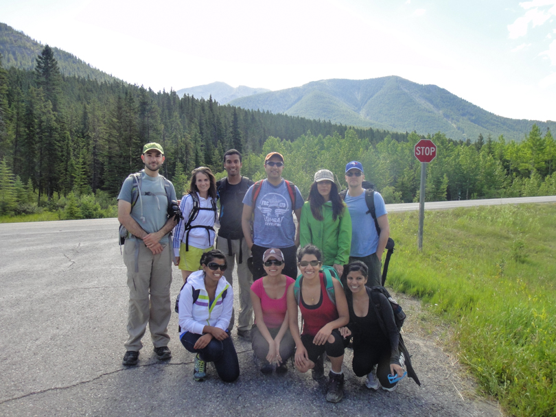
Fast forward to this past Sunday for the 3rd anniversary of the glorious day. And it was quite a large group too! We all met at the McD’s before exiting the city and once the troops were gathered, we headed out to Kananaskis to hike Baldy Pass. In reading about the hike online, it seemed like a nice one to do that wasn’t overly strenuous and offered a great place for lunch. It is also a pretty popular trail to do, and although it was affected by the flooding, it was open and accessible. The morning was beautiful and sunny, and the wonderful weather would continue throughout the day.
Awww
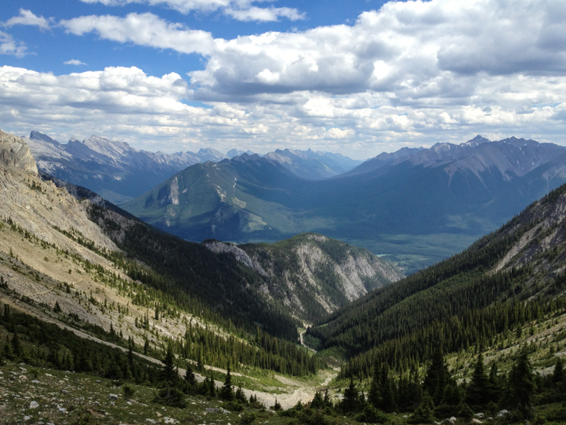
At around 10:30, we left the trailhead for the pass. We were quite the merry group, chatting along the way and enjoying each other’s company. The beginning of the hike was quite rocky and there was definitely evidence that things had changed post-flood. Then it was into the forest for a short but steady ascent to the pass. The views from the pass were quite nice. On the one side, grey rocky mountains; on the other, quite the view of Kananaskis forests (I’m not sure what the area is called :S). Then it was time for lunch.
Lunch time!
This was the best food spread yet! We had bread, cheese, pasta, prosciutto, turkey slices, strawberries, hummus, veggies, samosas, potato salad, gluten-free brownies, some other things, and of course, wine. Actually we had two great tasting wines this time, which were both polished off by the end of the lunch. Great job everyone- I definitely think we all ate well and enjoyed it! And of course, lunch culminated with someone (Laura, ahem, and Robin) seemingly drinking wine from the bottle. It’s not a birthday hike until that happens! Another year gone, another birthday hike completed. Until next year… 🙂
Great selection of wines
Stats:
Distance: 8 km roundtrip
Start: 10:30 am
End: 2:45, including our long celebratory lunch!
Elevation gain: 575 m or so
This weekend was my first double-hiking weekend of the summer. I’m quite tired and exhausted as I write this, but it felt good to test out my ankles and head out to the mountains. I figured it would be good preparation for my backpacking trip to Glacier National Park in a few weeks!
Hiking along Edith Pass Trail
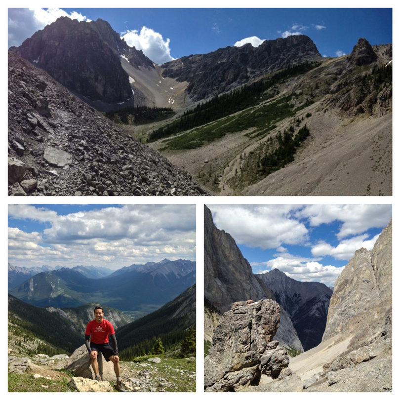
On Saturday, I recruited Robin and Jess and we were off to Banff to hike the Cory and Edith Pass trails (aka the Cory Pass Loop). It’s a hike that starts just a few kilometres west of Banff at the Fireside Picnic Area and is one of the popular ‘classic’ hikes to do in Banff National Park. The flooding in Kananaskis this year has prompted me to look into hikes in the Banff and Lake Louise areas. The Cory Pass Loop is noted as one of the most beautiful and scenic of Banff’s trails, but also one of the more difficult ones.
On the north side of Mount Edith
At the junction, we decided to proceed along Edith Pass trail. Apparently Cory Pass trail is the recommended way, but since I failed to do my research, heading to Edith Pass first seemed like the best choice. At this point in the hike we were dying already. Not because of any incline or the heat… nope, it was due to mosquitoes! I’ve never been swarmed like this before during a hike in the rockies. And there seemed to be something about the scent that I gave off, because they were more attracted to me than both Robin or Jess (although they got attacked a ton too!). Thank goodness for bug spray or I would have been eaten alive, more than I already was! (As I write this, I can’t stop itching my arms and legs… ahhhh!). The hike itself was quite nice as we made our way through forests on the east side of Mount Edith while making a steady ascent.
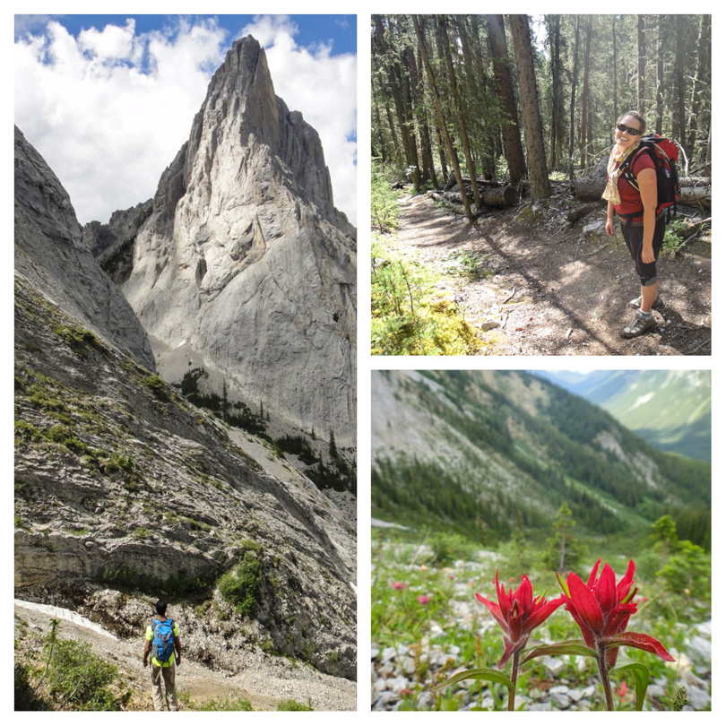
Gorgeous scenery during the Edith Pass LoopThe gargoyles
As we ascended the rocks to the highest point of Edith Pass, the gargoyles came into view. The formations don’t quite look like gargoyles, but they’re pretty awesome rock formations. It was also cool to be in the shadow of Mount Louis- that’s quite the rock face. Proceeding onward around the north side of Mount Edith, Mount Cory came into view and so did an amazing view of the southern mountains from Cory Pass. It was pretty breathtaking. Of course, we stopped for a few photos. Proud and jovial about our accomplishment, it was time to head back to the trailhead via the Cory Pass trail.
Proud and jovial… for now
All was well until we hit a seemingly dead end! Later I would google that although there’s some route finding to do, there’s nothing too crazy about the hike. But at that moment, we didn’t know where to go and decided we would head left onto an unmarked former trail and make a ridiculous descent down the side of Mount Edith. All seemed fine and good… sort of… until we started hitting fallen trees on the trail. Then overgrown foliage. Then the trail was covered in moss. Then there was no trail. I suddenly felt like something was wrong! For an official trail in Banff National Park, our path certainly did not look maintained. We made the decision to continue on, having descended so far after about 30 minutes. I began to panic and suddenly became worried. We were so far off course, and although we knew the general direction to the highway, we were facing old fallen trees and lots of obstacles. I played out scenarios in my mind- being blocked by a river; having a medical emergency due to a dangerous branch; or worse, running into a bear. Our bear calls were booming every few seconds. And since Jess and I were wearing shorts, our legs were destroyed by mosquitoes and numerous scratches. We climbed above and under so many branches. I do feel bad about losing my cool, but focus just set in, and all I wanted to do was get out of the forest. Suddenly I yelled, “What’s that!!?”. Robin and Jess were startled. Their heart rates accelerated. A bear? No… it was the trail! I have never been so happy to see a trail before (well, maybe I was just as happy when Robbie and I got lost on Tent Ridge last year). Suddenly our “Whooooops” to scare the bears away became “Whooohoooos” to describe our elation. And this trail was maintained. In fact, it was the same trail that we started on. We had managed to make a descent down a random side of Mount Edith back to the Edith Pass trail rather than continue on the Cory Pass trail back to the official junction. Argh! To top it all off, I managed to twist my right ankle. Not the bad left ankle… the good right ankle. Now both ankles hurt! Weeeee!
So in the end, this goes down as not the greatest second half of the hike, but without a doubt the views on Cory Pass are spectacular. Next time I’ll go the recommended way: Cory Pass first, followed by a gradual descent on Edith Pass trail. Although this way will have an 885 metre ascent in just 4.5 km, it sure would beat our random descent. Yep, that’s the way to do it. All hiccups aside, the Cory Pass Loop made for another great hike with great weather and great company :).
Almost back to the car, thank goodness…
Stats:
Start: 11:20 am
End: 6:30 pm (long day!)
Elevation gain:
Distance: 13 km
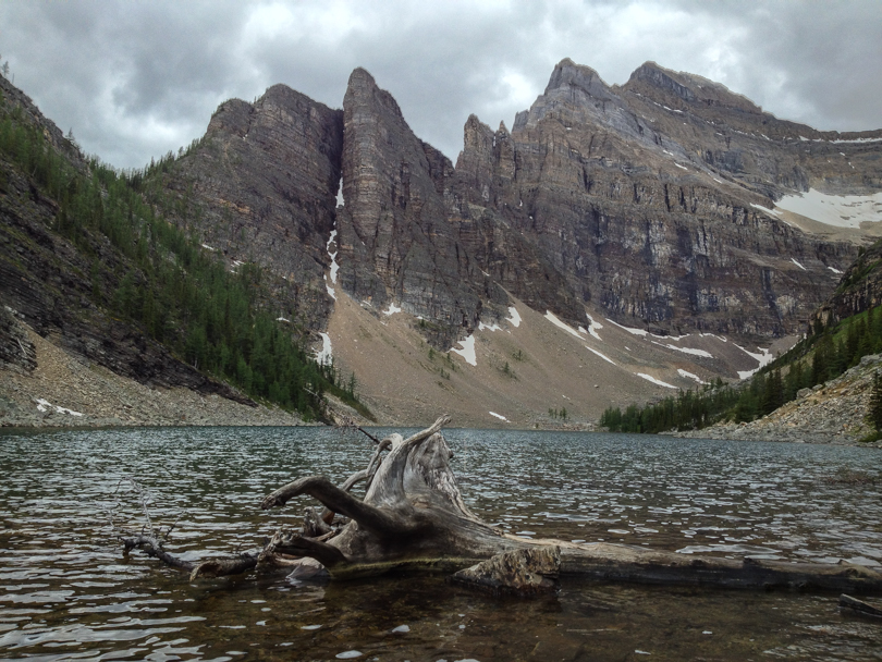
So this is going to be a quick entry for last Saturday’s hike :). Robbie’s cousin was in town and we were thinking about a good hike on which we could take her. The tea houses in Lake Louise are always a great option- scenic views; not too strenuous; forests, waterfalls, and glaciers; and snacks at the tea houses themselves (which we didn’t do). I’ve hiked them fairly recently (last August for the Banff Challenge), but it’s always a nice one to repeat. The plan: hike to the Lake Agnes Tea House to have lunch, then take the Highline Trail to the Plain of Six Glaciers Tea House, and then head back to the car. In the end, Nora loved it! At parts, I believe it reminded her of The Lord of the Rings. I can see why :). Our long day culminated with a sushi-gorging dinner. Best. Ever.
Ascending to the Plain of Six Glaciers Tea HouseHiking along the Highline Trail
Stats:
Start: 12:30 pm
End: 5:40 pm (with two 20 minute breaks at each of the tea houses)
Distance: 15.6 km loop
A late night of soca was not going to stand in my way of getting to the mountains! I woke up pretty tired on Sunday but Jess and I had planned to hike. The floods have made it a bit difficult to hike in Kananaskis, so we decided we’d venture out to the Banff and Lake Louise areas. I’ve always wanted to explore these areas a bit more, and Sunday was the perfect opportunity to do so.
Wild flowers along the trail
We stopped at the Banff Information Centre and asked for recommendations. From the Canadian Rockies Trail Guide book by Brian Patton and Bart Robinson, we chose Taylor Lake. Although it was described as “not particularly inspiring”, the view of the lake was sure to be gorgeous. So off we went, westbound on Highway 1, looking for the Taylor Creek Picnic Area turn-off near Castle Mountain and just before Lake Louise.
Hiking in the forest. Uninspiring.
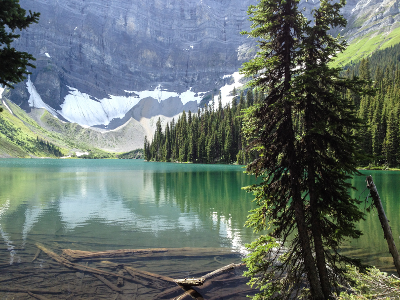
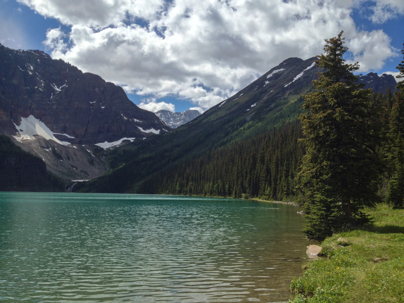
Once we were through the animal gates, it was a steady trek and incline to the lake. I can see why it would be described as uninspiring because there weren’t any mountain views along the way, but the wild flowers, forest, streams and bridges made for a nice and enjoyable hike. As with most glacial lakes nestled within an amphitheatre, the lake reveal was awesome, especially with Mount Bell towering in the background. We chatted with some people who were fishing in the area (who then graciously took our photo!), and then found a picnic table and stopped for lunch before heading back to the car. It was definitely a lovely afternoon :).
We made it! So pretty 🙂
Stats:
Start time: 1:20 pm
End time: 5:40 pm
GPS time: 3:53 minutes trekking time; ~30 minutes lunch at the lake
Elevation gain: 585 m (1920 ft)
Distance: 12.6 km round trip