Mount Indefatigable. Mind. Blown.

Dan and I approaching the south peak of Mount Indefatigable

Mount Indefatigable.

I can’t remember when I learned about this hike, but ever since I was informed of its epic-ness, I’ve wanted to conquer it. That was a couple of years ago. I remember saying to Dan last year that I had a good hike in mind, but winning the Big Mountain Challenge introduced other mountains to climb. Fast forward to this past weekend. I knew Dan and Aidan wanted a good hike. Better than good. An epic show-stopper, in fact. I also wanted a new mountain summit under my belt. Indefatigable was a clear choice.

It's decommissioned... but onward!
It’s decommissioned… but onward!

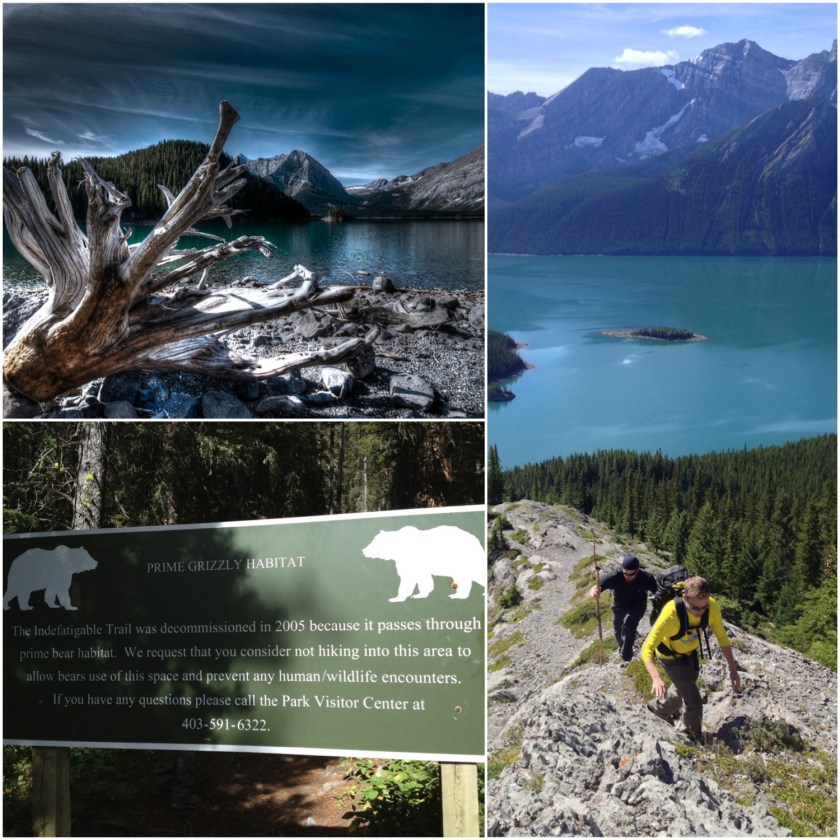
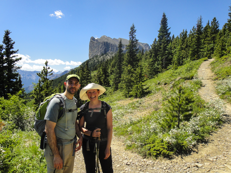
Before Saturday, I called the Kananaskis Visitor’s Centre to inquire about Indefatigable. It turns out the trail was decommissioned back in 2005. Did that mean we shouldn’t hike it? According to the guide, it’s definitely hike-able. Due to high grizzly activity in the area, the trail was constantly being closed when it was an official Kananaskis trail. Now that it’s decommissioned, it’s hike-at-your-own-risk. Thankfully the trail is extremely well travelled. So on Saturday, we were up early and made our way to the North Interlakes parking lot in Peter Lougheed Provincial Park with one simple goal: Conquer Mount Indefatigable. (Spoiler alert: No, we didn’t encounter any grizzlies thank goodness, but I was very much expecting that this would be the first time I would cross paths with one while hiking. Phew!)

Absolutely gorgeous views of the Kananaskis Lakes

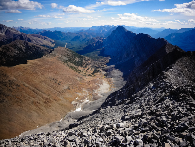
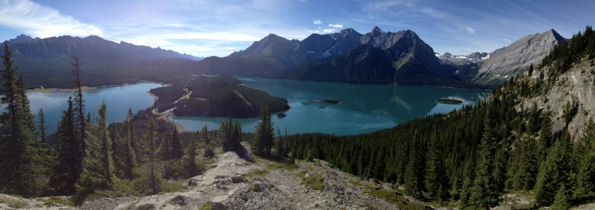
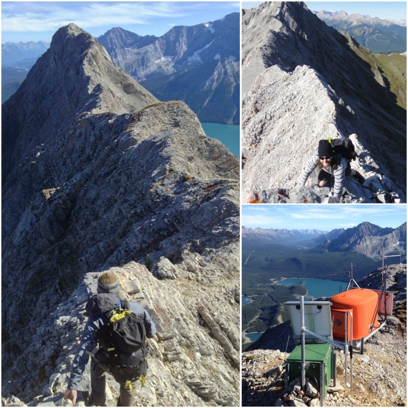
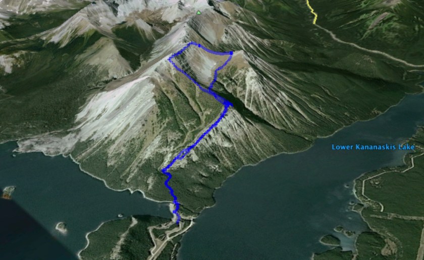
Mount Indefatigable has two peaks: the popular south peak, and the more difficult scramble to the north peak. An amazing ridge walk connects the two. When we started the trek, I thought we’d ascend to the south peak. We quickly emerged from the tree line to absolutely incredible views of the Kananaskis Lakes on either side. Mountains stretched far in the distance. We had hiked less than an hour and we were awe-struck. The weather was perfect that day too. Perhaps the giddiness helped boost our confidence. Or perhaps we were overzealous. Either way, we decided: Let’s just do the north peak and traverse the ridge! It was still early in the day, so why not?!

Wowza.
Wowza.

Here’s the thing: Alan Kane rates the north peak and traverse as a difficult scramble. According to his rating system, difficult scrambles require much handholding; steep, loose and exposed sections; smooth and down-sloping rocks; and risks of falling to your death. Up until Saturday, I had never completed a difficult Alan Kane scramble. Despite not having helmets for head protection, we decided to go for it. Smart? Not at all. Live and learn: a helmet is an upcoming purchase. But I’m glad we pushed through because it ended up being one of the most difficult and thrilling scrambles I’ve done in the Rockies. And boy had I been itching for a good scramble all season.

Approaching the north summit. Sketchy!

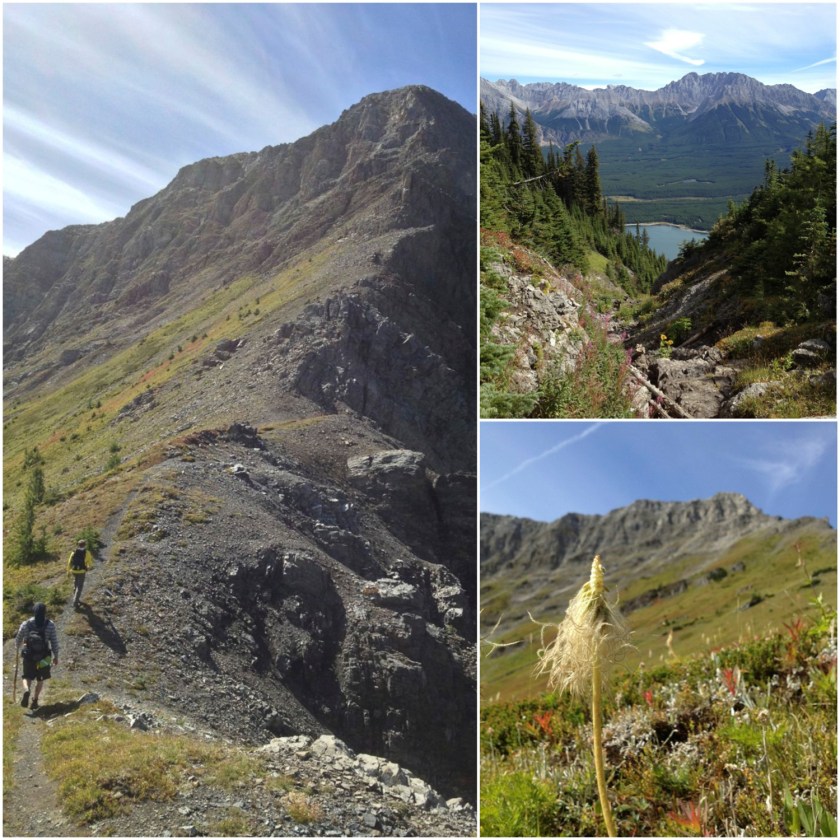
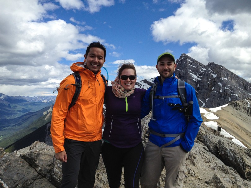
We trekked onward through forests while looking behind us at the amazing views. There were bear prints and evidence of ungulates (which I think were from the mountain goats we spotted!). We passed a dried up tarn and stopped for lunch right before the scramble to the north peak. To say that the scramble was sketch is a bit of an understatement. Dan, Aidan and I were in full concentration mode. A misstep could cause rocks to dislodge, and we did not want to be sliding down the mountain. Thankfully there was no one beneath us as Aidan accidentally sent rocks flying down the mountain. It also didn’t help that we took a wrong turn somewhere (or so we think). Hand-over-hand climbing went on for what seemed like a long time, but eventually we all made it to the summit. There would be no falling to our deaths on this mountain.

After surviving the moderate/difficult scramble, we were greeted with an amazing sight.

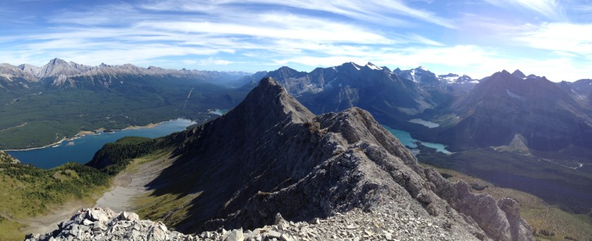
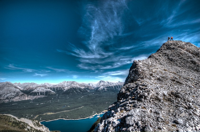
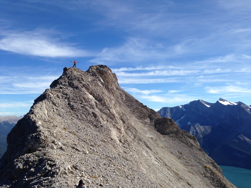
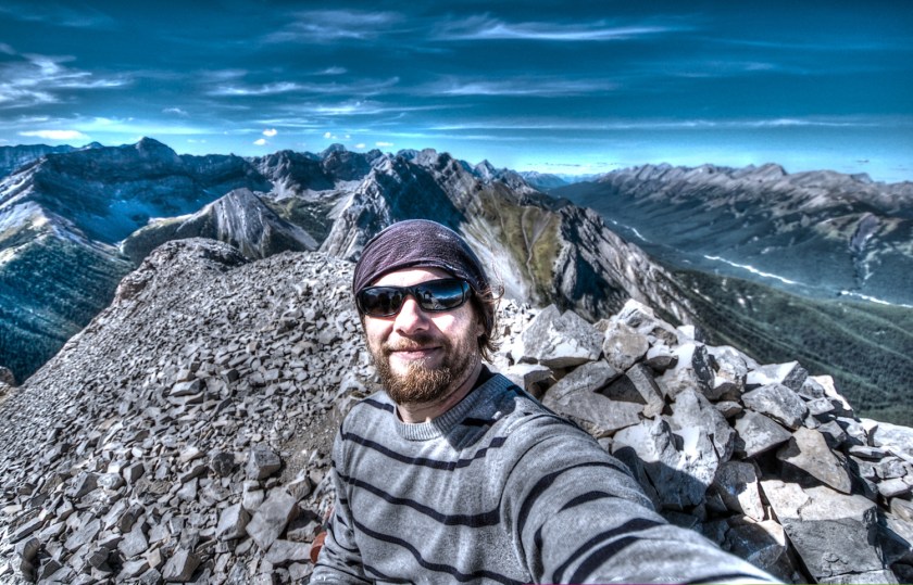
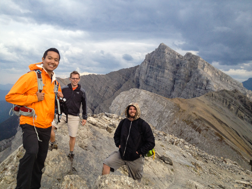
The views were absolutely incredible! I’ve hiked a lot of mountains, and I would rank the summit view in the top three, along with Mounts Sparrowhawk and Tyrwhitt. Maybe Eiffel too. We sat there for a while and took it all in. We also needed a rest- that scramble was intense! The traverse to the south peak was not nearly as scary as the ascent. In fact, I would say it wasn’t scary at all. Even though there were moments of crazy exposure and the ridge was narrow, there’s something amazing and oddly comforting about having steady footing on the ridge while the mountain drops on either side. In terms of ridge walks, this ranks highly along with Tent Ridge and Pocaterra Ridge, but takes the cake in terms of exposure and risk of falling. So much fun!

Traversing the ridge
Making our way to the south peak

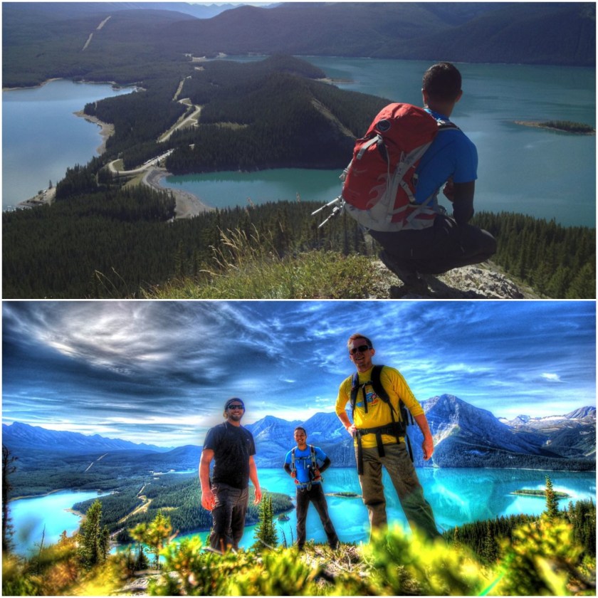
We snacked again at the South peak, and after remarking on how amazing the traverse had been, we made our descent. The views of the Kananaksis Lakes and surrounding mountains were just as amazing the second time around, now with different shadows and colours cast by the setting sun. The day ended 8 hours after we began, and the three of us were all smiles, extremely happy with our accomplishment. There were a lot of crazy awesome moments while conquering Mount Indefatiable… but what was the craziest thing I learned during the hike?

Aidan used to be a hair model for L’Oreal.

Mind. Blown!

Hair model for L'Oreal. True story.
Hair model for L’Oreal. True story.

Stats:

Start: 10:40 am

End: 6:40 pm

Elevation: 2670 m

Elevation gain: ~ 1000 m

Distance: ~ 9.5 km

Mount Indefatigable
Mount Indefatigable


Barfing up Gatorade and Prosciutto on Ha Ling

At the summit of Ha Ling

So after Dan and his brother Aidan arrived on Wednesday, I decided to take them to Ha Ling. Amazingly, Dan had never done that hike before (I figured I would have taken him at some point). Aidan had never been to Alberta before and Ha Ling has incredible views from the top in minimal hiking time, so I figured it would be a good intro for a weekend of hiking. Right after work on Thursday, we headed to Canmore and began the hike around 5:30 pm.

I’ve blogged about the hike itself before, so I’ll focus on something else. Aidan. It was great to meet Dan’s brother after hearing about him over the years, and he was eager to get to the mountains to hike. But apparently he hadn’t eaten a lot in the two days prior to the hike, and he was a bit off. He craved gatorade and drank about four bottles of it. He also had a prosciutto sandwich right before we booted it up the start of the mountain. So after gaining about 100 metres in elevation, he stopped to say that he needed a break. Then it happened. He barfed. And not just a little. A lot. About 5 or 6 full heaves-worth. Of red gatorade. And bread. And prosciutto. I wish I captured it on Instagram. He definitely left a little bit of himself on the mountain that day. We ended up hiking a bit with a guy named Ali, who told us he heard a bunch of belching at one point and thought it was a joke. Nope. No joke. Just a fountain of barf. On another note: descending Ha Ling in the dark with head lamps while it rains = sketchy and treacherous.

All in all, despite two rounds of vomit and a bit of rain, we had a great hike with an awesome sunset behind the mountains. Aidan and Dan agreed it was a good starter and training hike for what was to come on Saturday…. Mount Indefatigable!


Yamnuska In Lieu

Yamnuska2013-1It seems I’m about to lose count of the number of times I’ve hiked and will hike Yamnuska.

On Sunday, Robbie, Adriane and I ventured out to Heart Mountain, but we discovered that Heart Creek Trail had been completely wiped out due to flooding and rock slides. It was quite the sight :S. We ran into a Parks Canada guy who explained that most of the Kananaskis landscape has now been changed. Bridges are destroyed; rock slides and floods have completely altered the trails; and many areas are now inaccessible. I think he said something like 400 mm of rain in a 24 hour period (or maybe a 48 hour period?) plus an additional 300 mm of melting snow. With that crazy amount of rain in such a short period of time, flooding seemed inevitable. It was very sad news to say the least, and it will be many years before the Kananaskis trail system will be back to ‘normal (… after such an event, is it even possible?).

Yamnuska2013-2

He did recommend the east side of Yamnuska as a good place to go. We were itching to hike so of course we would venture off… and so would many other hikers. The lot was super busy, which made sense, seeing as it was one of the only trails in the area deemed safe for hikers. The sun was ridiculously hot that day and the mosquitoes were swarming like mad. Irregardless, it sure felt good to get out to the mountains! We didn’t reach the summit, but that’s okay- I think there will be many more opportunities this summer to conquer Yamnuska. Again.

Yamnuska2013-3

Stats

Start time: 12:10 pm
End time: 4:50 pm

Ha Ling: It’s Time for More Hiking!

HaLingJess-1There’s a part of me that’s a bit disappointed with the amount of hiking I’ve done this year. I guess it’s because I always want to head out to the mountains and sometimes life events happen that prevent this. For example, vertigo… vacations… road trips… gatherings… or just plain laziness, like today. It’s not that I don’t enjoy those things, because I definitely do, but there’s a yearning for the mountains that never goes away.

This is why it was so awesome to head to Ha Ling with Robbie and Jess yesterday and conquer this short climb. The weather was sunny and cloudy but perfect for a hike. We had all been itching to test our legs on the mountain. Now that the summer has started with the completion of Ha Ling, we can look forward to a summer ahead of many more mountain summits. And so today I proclaim: there will be many more summits to come! And my goal this year is to avoid, as best as possible, repeats of hikes. Why? Because there are just so many amazing ones out there!

One important thing we realized? “It’s not worth it if you’re going to die.” I suppose this is common sense. If there’s an activity where certain death is the outcome, it’s probably not worth it. Taking smart risks, on the other hand… well, those usually turn into quite the adventures!

Stats (according to Runkeeper):

Distance: 6.32 km
Duration: 3:53:49, starting at 2:10 pm
Pace: 36:59 min/km
Elevation: 756 m

Tyrwhitt: This Season’s Last Epic Hike

The rock archway on Mount Tyrwhitt

Mount Tyrwhitt. Ever since hiking Pocaterra Ridge last year, Paul and I have wanted to conquer Mount Tyrwhitt. From the cirque, the natural rock archway formation on the east ridge of Tyrwhitt is clearly visible. It just looks so cool. As we ascended Pocaterra, we said we’d hike to the top of Tyrwhitt at some point. That ‘some point’ was on Sunday.

View of Mount Tyrwhitt and the archway from the cirque

As usual, I was running slightly late. I blame this on the fact that I had to pick up a tall white mocha from Starbucks for Paul. My tardiness certainly had nothing to do with the fact that I also ordered two breakfast sandwiches for myself, a coffee, a sandwich for lunch, and picked up a vitamin water from Safeway. Eventually, we set out on the long drive to Highwood Pass.

Water in Pocaterra cirque
View from Grizzly col. Mount Tyrwhitt on the left; Pocaterra Ridge in the centre

The late morning was cool and chilly. It was a sign that winter was close by, and so we knew we needed to make the most of the day. Similar to the day before, the larches looked amazing. We began the hike and quickly found ourselves in the basin of Pocaterra cirque. Instead of heading right to Pocacterra Ridge, we veered left and hiked to Grizzly col. The landscape in this area is incredible. I did a quick read in Alan Kane’s Scrambles in the Canadian Rockies and discovered that the col sits on top of the Lewis Overthrust. The fault line runs from Glacier National Park in Montana to Mount Kidd, and this is why there is a sharp divide between ‘gentler shale slopes east of the col versus higher-angled grey limestone on Tyrwhitt’. Huh… learning something new every day.

Ascending Mount Tyrwhitt
The archway!
The archway!

Once at Grizzly col, it was another 250 m to the summit of Mount Tyrwhitt. The archway is about halfway up, so we kept to the east of the ridge and headed in that direction. This proved to be extremely nerve-wracking! Tyrwhitt is rated as a moderate scramble in the Kane book, and now I know why. The exposure was crazy. There was so much scree and loose rocks to climb. Every step forward was followed by a slight slide down the mountain. And one point, we came to an edge unexpectedly, and a misstep could lead to falling off the ridge. At first we thought we were headed the wrong way, but after consulting the book after the hike, we scrambled the recommended way. We ended up find the archway (thank goodness!), and after a few awesome photos, we continued the challenging ascent to the summit.

A breathtaking view
A breathtaking view
Kananaskis Lakes in the background

I know I say this on all mountains, but the views from the top were incredible. In fact, I think it ranks in the top 3 summit views that I’ve experienced in Alberta (Mount Sparrowhawk and Mount Eiffel are the others). The Kananaskis Lakes are in full view; Pocaterra cirque and the ridge lie to the north; and the valley of the Lewis Overthrust seemingly runs forever. It was a huge plus that we hiked in the fall because the colours were amazing. The icing on the cake? An official geocache greeted us at the top of Tyrwhitt. We signed our names and proclaimed that the scramble was worth it for the spectacular views!

Panoramic of the Kananaskis Lakes and Pocterra Ridge
A geocache!
A geocache!

It was then time for the sometimes painful and sketchy descent. I can recall lots of sliding and screeing. I had a rock crush my hand. Paul rammed his knee into another rock. With every step, the possibility of dislodging rocks and causing a bit of a rock slide was very real. At one point, a large rock was sent flying down the entire mountain. We felt so amateur, because that rock would have killed anyone in its path. It’s a good thing we were the only two climbing Mount Tyrwhitt that day. The scramble gave us a lot of stress and uneasiness :S.

Gorgeous!
Gorgeous!
The brutal descent
The brutal descent

After gaining steady footing again, we stopped to eat a late lunch. We were so frazzled by the scramble that we never paused to eat! So we sat on a few rocks among the trees, chatting about what we had just hiked and conquered. Then we continued onward, happy that we on target to reach the car in 6 hours flat. But then we ran into a problem. Before reaching the small lake, we encountered a group of Rocky Mountain sheep. Five of them, to be exact. They were en route from the rocks on the right of the trail to the forest on the left of the trail. I don’t think Rocky Mountain sheep are bothered by people that much, but these ones were definitely on alert, staying close together and keeping close eyes on us. Those shifty eyes were….. shifty. There was one sheep that looked like the ‘dad’, and he was the first to cross the trail. And then he just stopped. Right on the trail. And these sheep were huge! Paul readied the bear spray just in case. There was a lot of staring going on, and our attempts to stare down that sheep were not working. Once the ‘dad’ disappeared among the trees, we proceeded, but every time we did, he would come back out onto the trail. It was frightening to say the least. This little song and dance carried on for at least 10 minutes until we were joined by some other hikers. Power in numbers! We passed the sheep, very slowly. Their shifty eyes were on us the whole time. What a crazy experience! Between the possibility of bears while getting lost on Tent Ridge the day before, and then having the feeling of almost being charged by sheep with massive horns, it certainly was an eventful weekend.

The shifty eyes of a Rocky Mountain sheep

In total, it took 6 hours and 15 minutes to complete the hike (11:15 am – 5:30 pm). Mount Tyrwhitt is at an elevation of 2874 m. Even though the elevation gain is about 650 m, it was intense because of the scree/slab scramble. We’re so happy to have completed another moderate Kane scramble!

Mount Tyrwhitt: We conquered you!

I really enjoyed conquering Tyrwhitt with Paul. I can always count on him to hike the big peaks with me, and among all of the ridiculousness and laughter, he’s a safe hiker, a great friend, and I can always trust his judgement. Until the next big hike, Paul. Thanks for another great season filled with epic hikes!

Typical
Typical