A late night of soca was not going to stand in my way of getting to the mountains! I woke up pretty tired on Sunday but Jess and I had planned to hike. The floods have made it a bit difficult to hike in Kananaskis, so we decided we’d venture out to the Banff and Lake Louise areas. I’ve always wanted to explore these areas a bit more, and Sunday was the perfect opportunity to do so.
Wild flowers along the trail
We stopped at the Banff Information Centre and asked for recommendations. From the Canadian Rockies Trail Guide book by Brian Patton and Bart Robinson, we chose Taylor Lake. Although it was described as “not particularly inspiring”, the view of the lake was sure to be gorgeous. So off we went, westbound on Highway 1, looking for the Taylor Creek Picnic Area turn-off near Castle Mountain and just before Lake Louise.
Hiking in the forest. Uninspiring.
Once we were through the animal gates, it was a steady trek and incline to the lake. I can see why it would be described as uninspiring because there weren’t any mountain views along the way, but the wild flowers, forest, streams and bridges made for a nice and enjoyable hike. As with most glacial lakes nestled within an amphitheatre, the lake reveal was awesome, especially with Mount Bell towering in the background. We chatted with some people who were fishing in the area (who then graciously took our photo!), and then found a picnic table and stopped for lunch before heading back to the car. It was definitely a lovely afternoon :).
We made it! So pretty 🙂
Stats:
Start time: 1:20 pm
End time: 5:40 pm
GPS time: 3:53 minutes trekking time; ~30 minutes lunch at the lake
Elevation gain: 585 m (1920 ft)
Distance: 12.6 km round trip
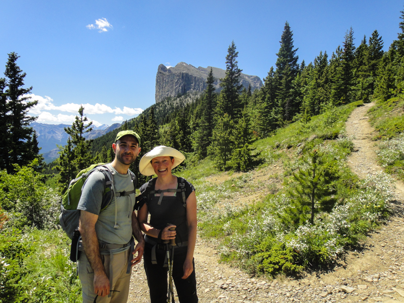
It seems I’m about to lose count of the number of times I’ve hiked and will hike Yamnuska.
On Sunday, Robbie, Adriane and I ventured out to Heart Mountain, but we discovered that Heart Creek Trail had been completely wiped out due to flooding and rock slides. It was quite the sight :S. We ran into a Parks Canada guy who explained that most of the Kananaskis landscape has now been changed. Bridges are destroyed; rock slides and floods have completely altered the trails; and many areas are now inaccessible. I think he said something like 400 mm of rain in a 24 hour period (or maybe a 48 hour period?) plus an additional 300 mm of melting snow. With that crazy amount of rain in such a short period of time, flooding seemed inevitable. It was very sad news to say the least, and it will be many years before the Kananaskis trail system will be back to ‘normal (… after such an event, is it even possible?).
He did recommend the east side of Yamnuska as a good place to go. We were itching to hike so of course we would venture off… and so would many other hikers. The lot was super busy, which made sense, seeing as it was one of the only trails in the area deemed safe for hikers. The sun was ridiculously hot that day and the mosquitoes were swarming like mad. Irregardless, it sure felt good to get out to the mountains! We didn’t reach the summit, but that’s okay- I think there will be many more opportunities this summer to conquer Yamnuska. Again.
Earlier today I was perusing this and that at MEC when a friend texted me: “Are you affected by the flooding?” This was the first time I had heard about a flood, but it certainly would not be the last. I took to Twitter and had no idea that parts of Calgary were being evacuated due to rising water levels near the Elbow River. Six communities to start, including Mission. I called a few friends right away who lived in Mission. They also didn’t know. It turns out they would have to gather some things from home and get ready to leave their apartment for 72 hours.
In the many hours to come, I would learn much more about this impending disaster. At first, I wondered how serious it could really be. But then I learned that the situation was definitely more dire. A state of emergency was declared for many areas. Areas like High River, Black Diamond, and Bragg Creek had been hit quite hard, with ridiculous amounts of flooding and loss of homes. Cougar Creek in Canmore had dangerously high levels and destroyed homes as well. The TransCanada Highway was closed both east and west of Banff and residents and visitors of Banff were told they should stay put. The highway collapsed outside of Canmore. Videos and photos of those areas show quite a bit of damage, and it’s difficult to believe that rain and melting snow could do this in Alberta. The water levels continued to rise in Calgary. One by one, communities were ordered to evacuate.
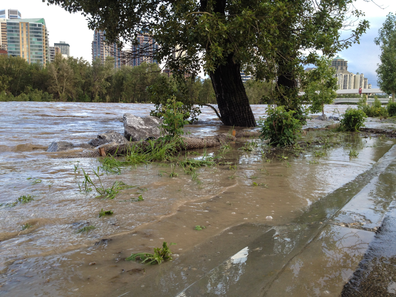
After what seemed like hours of watching videos and reading Twitter feeds, I decided to go take a look myself. I headed down to Edworthy Park to take photos of the Bow River. I was not the only one. People were parking and getting out of their cars to look at the super high water levels. It’s very odd to see; on a normal day, there are mini islands in the Bow River and the banks of the river are quite high. Today, they were all non-existent and completely flooded. I then headed to a vantage point overlooking Bowness, which was being evacuated. I scoured the city for other views: the stairs above Sunnyside; the 14th street overpass; and eventually, Memorial Drive and 10th street in Kensington. This is where I saw the craziest flooding of the night. The water had risen over the banks and were spilling onto the paths. Crazy! Apparently the water levels will be up to 3 times as much as the flood in 2005 when all is said and done. Though I wasn’t here in 2005, it sounds like it was bad.
I now find myself at 3 am refreshing Twitter and continuing to read what many Calgarians are saying and showing about this flood. There have been many photos from Bowness, Mission, Memorial Drive, Discovery Ridge, and many other locations. As of now, 25 communities have been evacuated. Travel to the downtown has been discouraged. Transit has been disrupted. Bridges have been closed. The rain is expected to continue.
What I have found absolutely incredible about this situation is not the sheer force of the water, or how quickly the floods are rising, or how much rain continues to fall. I have been amazed by and proud of the people of Calgary. There has been an outpouring of support about how to help with clean-up efforts; Calgary Police (@CalgaryPolice) and the City of Calgary (@cityofcalgary), whose efforts throughout the day and night have been ridiculously impressive, have had to turn away volunteers because there have been just too many offerings; and the community has offered up their homes through kijiji or #yychelps on Twitter to anyone who needs a place to stay for the next few nights. Mayor Nenshi (@nenshi) cut his trip to Toronto, flew back, and an hour ago (2 am) he was touring around the flooded areas of Calgary with John Mar (@aldjohnmar) and Richard Pootmans (@pootmans). At this moment, I believe they’re investigating the dam at Glenmore. All of the folks involved have worked tirelessly to keep Calgarians informed and up to date. Information has travelled at light speed and Calgarians have evacuated safely as a result. The mayor and his staff have been amazing, and I have been so impressed with and thankful for their efforts and work. The generosity of Calgarians has been outstanding and incredibly moving to say the least. It’ll be interesting to see what I wake up to tomorrow. But today, I’ve realized once again how much I love this city.
The Bow River at Edworthy ParkLooking over to Bowness, one of the communities evacuatedProtecting SunnysideFlooding over path in KensingtonWoah. Flooding in KensingtonLooking toward BownessAlong the bike path on Memorial DriveLooking toward the Stampede GroundsDebris. Lots of debris.
There’s a part of me that’s a bit disappointed with the amount of hiking I’ve done this year. I guess it’s because I always want to head out to the mountains and sometimes life events happen that prevent this. For example, vertigo… vacations… road trips… gatherings… or just plain laziness, like today. It’s not that I don’t enjoy those things, because I definitely do, but there’s a yearning for the mountains that never goes away.
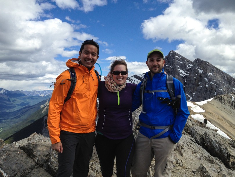
This is why it was so awesome to head to Ha Ling with Robbie and Jess yesterday and conquer this short climb. The weather was sunny and cloudy but perfect for a hike. We had all been itching to test our legs on the mountain. Now that the summer has started with the completion of Ha Ling, we can look forward to a summer ahead of many more mountain summits. And so today I proclaim: there will be many more summits to come! And my goal this year is to avoid, as best as possible, repeats of hikes. Why? Because there are just so many amazing ones out there!
One important thing we realized? “It’s not worth it if you’re going to die.” I suppose this is common sense. If there’s an activity where certain death is the outcome, it’s probably not worth it. Taking smart risks, on the other hand… well, those usually turn into quite the adventures!
Stats (according to Runkeeper):
Distance: 6.32 km
Duration: 3:53:49, starting at 2:10 pm
Pace: 36:59 min/km
Elevation: 756 m
After a fairly lazy April filled with lots of TV watching (Spartacus!- an amazing show…) and a relaxing trip home, I decided enough was enough. True, things have been a bit up in the air lately and the down time was much needed. But a month is all I can do. It’s time to kick it into gear. I’m slowly going to get into the swing of things again and keep myself busy, active and social. To start, I decided to take a day trip out to Banff yesterday for some fresh air and inspiration from the mountains. It definitely did some good.
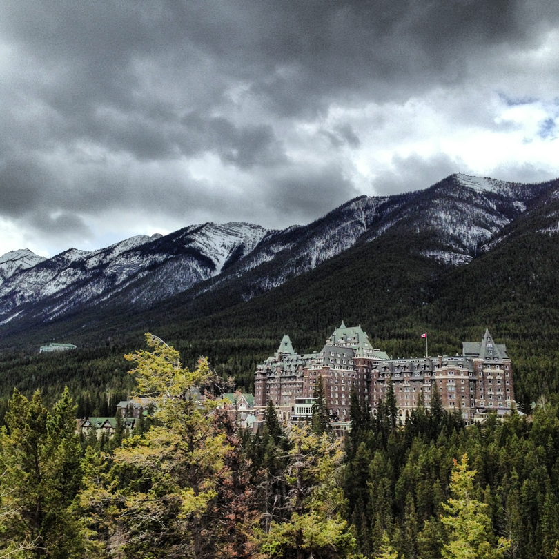
This hotel continues to impress 🙂
I decided on the Hoodoo Trail, which starts at the Surprise Corner parking lot on Buffalo Street. After admiring the view of the Fairmont Banff Springs Hotel, I made my way to the trailhead. I’ve done many hikes, and though this trail was beautiful, I wouldn’t place it at the top of my list of must-do hikes. But walking along the river, past Tunnel Mountain, and through some meadows and forest was very nice.
A lovely walk on the Hoodoo Trail
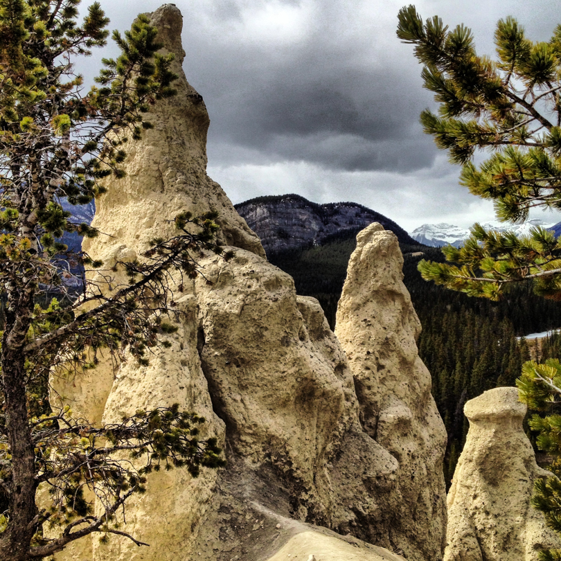
I didn’t realize you could drive right to the hoodoos, so it was a bit shocking to end the hike beside a road and parking lot :o|. Nevertheless, the hoodoos themselves were impressive. The Hoodoo Trail took about 2.5 hours (4.2 km each way) at a pretty leisurely pace. It wasn’t too strenuous, having only 60 metres of elevation gain, but it made for a refreshing excursion.
Standing among the hoodoos
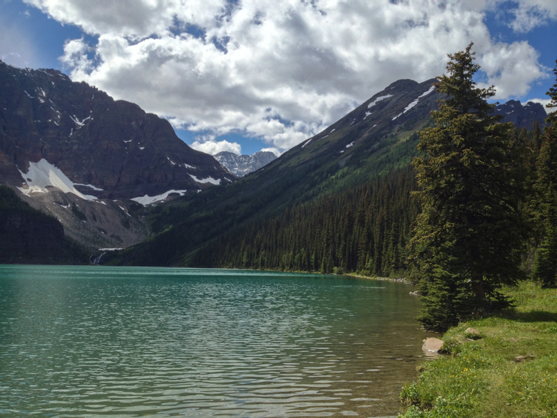
Then it was off to see Lake Minnewanka. After 4 years in Calgary, I finally went to the lake :). Similar to many lakes in the Rockies, the scenery is gorgeous. I intended to make my way to Steward Canyon, but alas, I had to jet back to the city. There’s always next time!


 It seems I’m about to lose count of the number of times I’ve hiked and will hike Yamnuska.


 There’s a part of me that’s a bit disappointed with the amount of hiking I’ve done this year. I guess it’s because I always want to head out to the mountains and sometimes life events happen that prevent this. For example, vertigo… vacations… road trips… gatherings… or just plain laziness, like today. It’s not that I don’t enjoy those things, because I definitely do, but there’s a yearning for the mountains that never goes away.