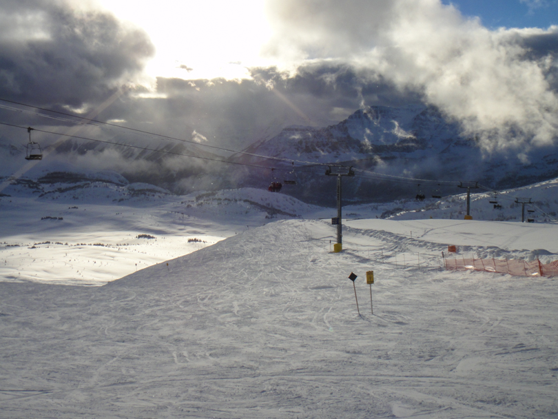
I’ve been here almost 4 years. In that time, I’ve managed to endure 8 month winters without immersing myself into winter activities. Well, that’s slowly starting to change. It may not be the end of November as yet, but here in Calgary and the surrounding areas, we’ve had lots of snow. And so far this year, I’ve managed to go snowshoeing, snowboarding, and this past Sunday, downhill skiing at Sunshine Village.
Similar to last year’s experience, Sunshine was quite sunny and the snow was fluffy. This made for an awesome skiing experience. Being a beginner, I did fall once, but overall I think I did pretty well. And the views while riding the gondolas and chair lifts are pretty spectacular, especially when the sun rays are beaming down on the snow and everything glistens. Overall, an incredible day with about eleven runs followed by the ski-out. I can’t wait to go again :).
Mount Tyrwhitt. Ever since hiking Pocaterra Ridge last year, Paul and I have wanted to conquer Mount Tyrwhitt. From the cirque, the natural rock archway formation on the east ridge of Tyrwhitt is clearly visible. It just looks so cool. As we ascended Pocaterra, we said we’d hike to the top of Tyrwhitt at some point. That ‘some point’ was on Sunday.
View of Mount Tyrwhitt and the archway from the cirque
As usual, I was running slightly late. I blame this on the fact that I had to pick up a tall white mocha from Starbucks for Paul. My tardiness certainly had nothing to do with the fact that I also ordered two breakfast sandwiches for myself, a coffee, a sandwich for lunch, and picked up a vitamin water from Safeway. Eventually, we set out on the long drive to Highwood Pass.
Water in Pocaterra cirqueView from Grizzly col. Mount Tyrwhitt on the left; Pocaterra Ridge in the centre
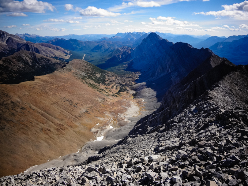
The late morning was cool and chilly. It was a sign that winter was close by, and so we knew we needed to make the most of the day. Similar to the day before, the larches looked amazing. We began the hike and quickly found ourselves in the basin of Pocaterra cirque. Instead of heading right to Pocacterra Ridge, we veered left and hiked to Grizzly col. The landscape in this area is incredible. I did a quick read in Alan Kane’s Scrambles in the Canadian Rockies and discovered that the col sits on top of the Lewis Overthrust. The fault line runs from Glacier National Park in Montana to Mount Kidd, and this is why there is a sharp divide between ‘gentler shale slopes east of the col versus higher-angled grey limestone on Tyrwhitt’. Huh… learning something new every day.
Ascending Mount TyrwhittThe archway!
Once at Grizzly col, it was another 250 m to the summit of Mount Tyrwhitt. The archway is about halfway up, so we kept to the east of the ridge and headed in that direction. This proved to be extremely nerve-wracking! Tyrwhitt is rated as a moderate scramble in the Kane book, and now I know why. The exposure was crazy. There was so much scree and loose rocks to climb. Every step forward was followed by a slight slide down the mountain. And one point, we came to an edge unexpectedly, and a misstep could lead to falling off the ridge. At first we thought we were headed the wrong way, but after consulting the book after the hike, we scrambled the recommended way. We ended up find the archway (thank goodness!), and after a few awesome photos, we continued the challenging ascent to the summit.
A breathtaking viewKananaskis Lakes in the background
I know I say this on all mountains, but the views from the top were incredible. In fact, I think it ranks in the top 3 summit views that I’ve experienced in Alberta (Mount Sparrowhawk and Mount Eiffel are the others). The Kananaskis Lakes are in full view; Pocaterra cirque and the ridge lie to the north; and the valley of the Lewis Overthrust seemingly runs forever. It was a huge plus that we hiked in the fall because the colours were amazing. The icing on the cake? An official geocache greeted us at the top of Tyrwhitt. We signed our names and proclaimed that the scramble was worth it for the spectacular views!
Panoramic of the Kananaskis Lakes and Pocterra RidgeA geocache!
It was then time for the sometimes painful and sketchy descent. I can recall lots of sliding and screeing. I had a rock crush my hand. Paul rammed his knee into another rock. With every step, the possibility of dislodging rocks and causing a bit of a rock slide was very real. At one point, a large rock was sent flying down the entire mountain. We felt so amateur, because that rock would have killed anyone in its path. It’s a good thing we were the only two climbing Mount Tyrwhitt that day. The scramble gave us a lot of stress and uneasiness :S.
Gorgeous!The brutal descent
After gaining steady footing again, we stopped to eat a late lunch. We were so frazzled by the scramble that we never paused to eat! So we sat on a few rocks among the trees, chatting about what we had just hiked and conquered. Then we continued onward, happy that we on target to reach the car in 6 hours flat. But then we ran into a problem. Before reaching the small lake, we encountered a group of Rocky Mountain sheep. Five of them, to be exact. They were en route from the rocks on the right of the trail to the forest on the left of the trail. I don’t think Rocky Mountain sheep are bothered by people that much, but these ones were definitely on alert, staying close together and keeping close eyes on us. Those shifty eyes were….. shifty. There was one sheep that looked like the ‘dad’, and he was the first to cross the trail. And then he just stopped. Right on the trail. And these sheep were huge! Paul readied the bear spray just in case. There was a lot of staring going on, and our attempts to stare down that sheep were not working. Once the ‘dad’ disappeared among the trees, we proceeded, but every time we did, he would come back out onto the trail. It was frightening to say the least. This little song and dance carried on for at least 10 minutes until we were joined by some other hikers. Power in numbers! We passed the sheep, very slowly. Their shifty eyes were on us the whole time. What a crazy experience! Between the possibility of bears while getting lost on Tent Ridge the day before, and then having the feeling of almost being charged by sheep with massive horns, it certainly was an eventful weekend.
The shifty eyes of a Rocky Mountain sheep
In total, it took 6 hours and 15 minutes to complete the hike (11:15 am – 5:30 pm). Mount Tyrwhitt is at an elevation of 2874 m. Even though the elevation gain is about 650 m, it was intense because of the scree/slab scramble. We’re so happy to have completed another moderate Kane scramble!
Mount Tyrwhitt: We conquered you!
I really enjoyed conquering Tyrwhitt with Paul. I can always count on him to hike the big peaks with me, and among all of the ridiculousness and laughter, he’s a safe hiker, a great friend, and I can always trust his judgement. Until the next big hike, Paul. Thanks for another great season filled with epic hikes!
Sigh, it’s been so long since I wrote my last post. Truth be told, once the Big Mountain Challenge was over, I was on a bit of a self-imposed hiatus from anything social media. I’ve never done so much blogging, facebooking and tweeting in my life! But now it’s time to get back into the swing of things. I figured I’d start slow, so this is going to be a pretty short post.
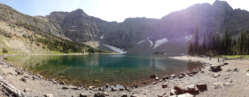
Last weekend, I visited Waterton Lakes National Park with a few friends. I was there earlier this year as the bears were awaking and the ticks were in full force. This time, the trip had a specific purpose: To hike to Crypt Lake, which was on my list.
Ever since I heard about the Crypt Lake hike, I was sold. And the hike certainly did not disappoint! After boarding a ferry from the harbour in Waterton, we headed to Crypt Landing. We had about 7 hours to complete the entire hike, which was definitely enough time. There were quite a few people on the ferry, all eager and excited. The weather was cooperating, and we were pumped!
The hike was a gradual climb among one of the most beautiful areas in Canada. Actually, it was voted “Canada’s Best Hike” in 1981! Along the way, we journeyed through forests, passed waterfalls, crawled through a natural tunnel created by erosion, traversed along a rock face while holding onto a steel cable, and was then rewarded with the amazingly bluish waters of Crypt Lake. The scenery was gorgeous the entire time, and the views of the colourful valley was incredible. We even caught sight of a mountain goat on the side of the mountain. Very cool!
All in all, I would recommend Crypt Lake for anyone wanting an amazing day hike that’s challenging enough to feel like work has been done, but do-able enough to ensure a sense of accomplishment! The total time for our hike, with stops for breaks and lunch, was 6 hours and 40 minutes. It took 3 hours from Crypt Landing to the lake. There’s a 700 metre elevation gain and a roundtrip distance of 17.2 km. Not too bad for a day’s work, and definitely worth it. And just like that… Crypt Lake, you’re off the list!
Oh Mount Temple… how have you managed to elude me so?
On Wednesday, when the weather was all clear skies and perfect, we were unable to hike Temple due to bear restrictions. But Mount Temple stood like an incredible beauty. The snow that stood atop the mountain glistened in the sun. Gazing at Temple was as mesmerizing as listening to Beyonce belt out a ballad. But on Sunday, when we were slated to make attempt #2, Temple turned into its alter ego. A fresh snowfall the previous night added a complication to the hike. And the wind was fierce. Sasha Fierce. Would we be able to hike Mount Temple? Or was it untouchable like the unstoppable Sasha Fierce??
What’s that Jeff?? We’re hiking Temple?!?
To backtrack slightly, on Saturday while Dan and I were hiking the Tea House Highline Challenge, I received a call from Jeff from Banff Lake Louise Tourism and The Real Banff. He informed us that we’d be making another go at Mount Temple, and that our guide Joe from www.mountainguide.com would be at the Chateau for 5:30 am. Sweet! Since we needed a 4th, my good friend Paul made his way to Lake Louise, ready with all of his gear, and stoked to tackle Mount Temple!
Ready for Temple with a helmet, ice axe and crampons
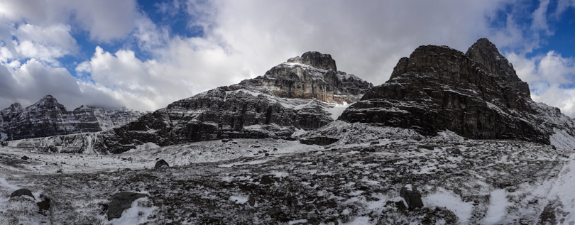
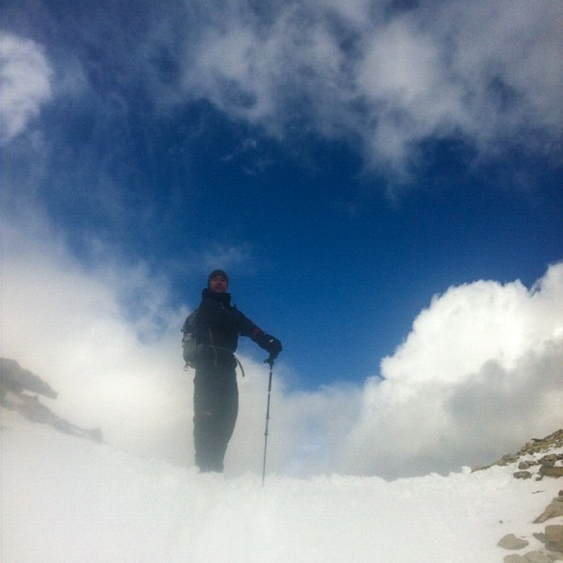
The next morning, we left the Moraine Lake parking lot at 6:15 am and hiked through the Larch Valley. It was dark at the start, but as the light began to illuminate our surroundings, we quickly realized that it was a pretty special hiking area. In the fall, the Larch Valley is beautiful, especially when the larches turn a golden colour. Mount Temple, Mount Eiffel and Mount Pinnacle surround Eiffel Lake and the trail up to Sentinel Pass, so it was pretty awesome to see these gigantic peaks around us while we hiked. It snowed the night before, and so the trail was covered with a fresh blanket of snow. I’ve done the hike to Sentinel Pass before, but I’m always amazed how different the mountains look with snow. The clouds were dense the whole time, and it was windy! Mount Temple’s summit was hidden within the clouds. At over 3500 metres, it’s a beast!
Joe assessing the climb to the summit of Mount TemplePaul, Dan and I at Eiffel Lake, before Sentinel PassA snowy hike up Sentinel PassView from Sentinel Pass
The hike up was a bit uneasy due to the snow, but we persevered onward. Once we arrived at Sentinel Pass, the wind was relentless. But looking up at Mount Temple, the wind would be even more fierce. Sasha Fierce. That wind would be unforgiving for the next many many hours if we ascended. So we made the safety call to forgo Mount Temple, yet again. I’m okay with that. Safety first, folks! But Mount Temple has now elluded me a second time. Argh.
After Sentinel Pass, backtracking to start ascending EiffelMount Eiffel (middle) and Mount Pinnacle (right)Mount Eiffel, Mount Pinnacle, and cloud covered Mount TempleA snowy scramble to the summit of Mount Eiffel
The day was not over yet. Instead, we would try to summit nearby Mount Eiffel. Once I looked up at Mount Eiffel from the lake, it seemed like a very acceptable alternative. It was epic! So off we went to make the ascent of snow covered Mount Eiffel. I’ve never hiked a mountain in that much snow before, but it was quite a fun day, and the scrambling near the top was awesome. Don’t get me wrong, we were pretty tired, having just hiked to the top of Sentinel Pass, but once we reached the top, the views were unlike other hikes I’ve done. All of the mountains around us were covered with snow, and Mount Temple loomed just an arm’s length away. By this time, the sun was shining through, and the view of Temple’s summit was now visible. I can only describe it as incredible.
Joe, Paul, me and Dan at the summit of Mount EiffelPanoramic from the summitPanoramic with Mount Temple in viewStopping for photos and lunch at the summit of Mount EiffelAt the summit of Mount Eiffel. Temple totally photobombed my shot!
By the end of they day, we hiked to Sentinel Pass (elevation gain of 732 metres from the trailhead), turned back, bushwhacked to the start of the ridge to Mount Eiffel, reached the summit of Eiffel (3084 metres; elevation gain of 1230 metres from the trailhead), and navigated back through the Larch Valley as the snow melted. It was a very long hiking day of 10 hours. Despite the slips and wind and cold, it was most definitely worth every step!
“Gentlemen, we have conquered Mount Eiffel”Making the long and slippery descentBack at beautiful Moraine Lake after 10 hours of hiking
But it’s not over, Mount Temple. Mark my words. I can be Sasha Fierce too. You’ve been warned!
And speaking of Beyonce, it’s her birthday today, September 4th. She turns 31!
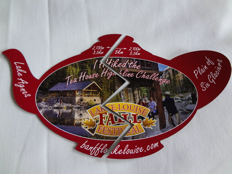
“I Hiked the Tea House Highline Challenge” souvenir 🙂
It was another awesome day today. I came across something while I was perusing The Real Banff website called the Lake Louise Highline Tea House Challenge. I like a challenge, so I asked Dan if he’d like to partake in this challenge. Of course he said yes. And it was awesome. Basically, you needed to hike to both of the tea houses in the Lake Louise area- the Plain of Six Glaciers Tea House and the Lake Agnes Tea House- and collect half of a magnet at each tea house to create a unique souvenir.
Dan, Suzanne and I at the Plain of Six Glaciers Tea HouseThe kitchen in the Plain of Six Glaciers Tea HouseYum. Pies.Eating a tuna salad sandwich with a mocha
The scheduled activity for the day was a lunch date with Suzanne, the owner of the Plain of Six Glaciers Tea House. She explained a little about the history of the tea house, and what it takes to run the tea house throughout the summer. It was all quite interesting to hear, and she was so nice! After earning the first half of the magnet, we then hiked the Highline Trail to Lake Agnes where we collected the second half of the magnet to form the “I Hiked the Tea House Highline Challenge”. Yippiie!
As if one challenge isn’t enough… why not do two? 🙂
En route from the Plain of Six Glaciers Tea House to the Lake Agnes Tea HouseThe Lake Agnes Tea HouseLake Agnes
 I’ve been here almost 4 years. In that time, I’ve managed to endure 8 month winters without immersing myself into winter activities. Well, that’s slowly starting to change. It may not be the end of November as yet, but here in Calgary and the surrounding areas, we’ve had lots of snow. And so far this year, I’ve managed to go snowshoeing, snowboarding, and this past Sunday, downhill skiing at Sunshine Village.